About Adriatic S. Nautical Charts
*** For people who are looking for appealing charts, features like seamless scrolling, comprehensive coverage with good chart view management, track recording and safety feature (MOB), Seawell marine navigation...
*** For people who are looking for appealing charts, features like seamless scrolling, comprehensive coverage with good chart view management, track recording and safety feature (MOB), Seawell marine navigation applications are the best choice. This application provides maps to make life easier and more enjoyable for sailors, fishermen, divers, boaters and cruisers.
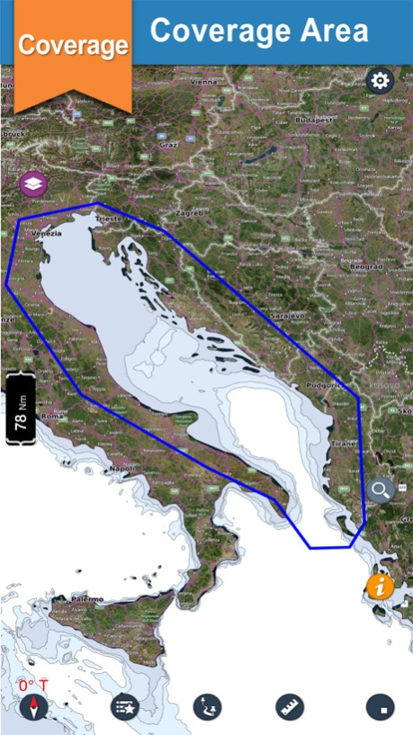
*** Comprehensive coverage
Coverage of the chart is extensive and detailed: ***Adriatic Sea-Our chart covers Tirane, Podgorica, Venezia, Trieste, Croatia, Laudonov Gaj, Virsko More, Dera, Jasik, Molo Foraneo, Sc.i Guaceto, Diga di Ponente, Lago di Varano, T.Sinarca, Campli, Salina di Cervia and many more.
*** Seamless scrolling:
With Seawell chart application you can zoom in and out without having to look for and load different charts. You can still scroll/zoom even when the favorites list or track list view is open. You can also mark or add favorite spots, dynamically without going back and forth to the chart.
*** Chart view management
Lots of care has been taken to avoid clutter of icons, to utilize the full view of the chart to display only the map. With a single ON/OFF button, you can have full chart clear view. All the buttons on the chart are configurable to be turned off from the view in the settings
*** Track recording
√ Knowing where you’ve been helps significantly when visualizing where you’re going. Track recording is also a useful supplement to a log.
√ Intuitive interface to turn a track ON/ OFF, edit details & delete.
√ Intuitive track detail view helps you to start / stop / pause / continue your track recording.
√ GPS Tracking with north up / Course up!
Three modes of GPS tracking, Red denotes user location centered and north up, yellow denotes user location is tracked but not centered with north up and blue denotes user location centered and map is rotated in course UP direction.
*** Favorites:
√ You can simply use your finger to tap positions on the chart where you want favorites.
√ Favorites list is also easy to use.
√ A picture is one thing, which tells more about your favorite places and you can share the same with your friends and families with different formats such as KML, KMZ and GPX
*** Distance measure
Measuring distances, not just from the boat, is clearly a key part of any navigation system. Check how easy to use this.
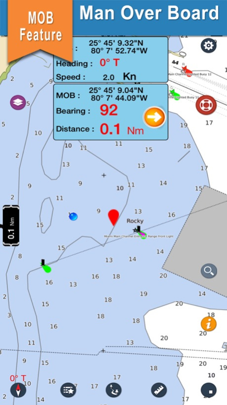
*** MOB function (Man Overboard)
Will show you the way back to MOB and position can be used by the emergency services.
*** Other Features:
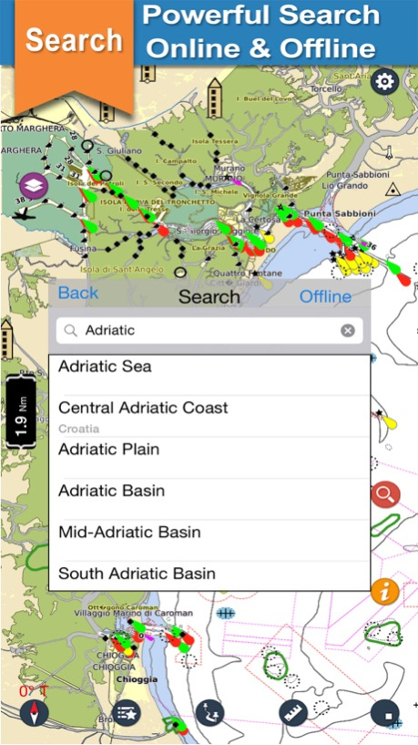
√ Online and Offline Search
√ Speed of boat
√ Add Images in favorites
√ Seawell has multiple overlays: Offline, Hybrid,Topo and Street mode
√ Offline: Only offline maps will be displayed which are useful in situations where there is no Internet connectivity. .
√ Hybrid: Land areas are covered by satellite imagery.
√ Street: Land areas are covered by open street maps
√ Topo : Land areas are covered by topographic maps
***NOTE: "Continued use of GPS running in the background can decrease battery life”
“Turn off GPS when not in use”
Oct 6, 2017
Version 3.1
This app has been updated by Apple to display the Apple Watch app icon.
New Topo overlay added.
Co-ordinates now in Degree Minutes.
Previous Versions
Here you can find the changelog of Adriatic S. Nautical Charts since it was posted on our website on 2016-10-29 04:10:31.
The latest version is 3.1 and it was updated on 2024-04-19 23:49:46. See below the changes in each version.
Adriatic S. Nautical Charts version 3.1
Updated At: 2017-10-06
Changes: Oct 6, 2017 Version 3.1
New Topo overlay added.
Co-ordinates now in Degree Minutes.
Adriatic S. Nautical Charts version 3.1
Updated At: 2017-10-06
Changes: 6 Oct 2017 Version 3.1
New Topo overlay added.
Co-ordinates now in Degree Minutes.
Adriatic S. Nautical Charts version 3.1
Updated At: 2017-10-06
Changes: Oct 6, 2017 Version 3.1
This app has been updated by Apple to display the Apple Watch app icon.
New Topo overlay added.
Co-ordinates now in Degree Minutes.
Adriatic S. Nautical Charts version 3.1
Updated At: 2017-10-06
Changes: Oct 6, 2017 Version 3.1
This app has been updated by Apple to use the latest Apple signing certificate.
New Topo overlay added.
Co-ordinates now in Degree Minutes.
Adriatic S. Nautical Charts version 2.4.2
Updated At: 2016-01-13
Adriatic S. Nautical Charts version 3.1
Updated At: 1970-01-01
Changes: 2017년 10월 6일 Version 3.1
New Topo overlay added.
Co-ordinates now in Degree Minutes.
Adriatic S. Nautical Charts version 3.1
Updated At: 1970-01-01
Changes: 6 de oct. de 2017 Version 3.1
New Topo overlay added.
Co-ordinates now in Degree Minutes.
Adriatic S. Nautical Charts version 3.1
Updated At: 1970-01-01
Changes: 2017年10月6日 Version 3.1
New Topo overlay added.
Co-ordinates now in Degree Minutes.
Adriatic S. Nautical Charts version 3.1
Updated At: 1970-01-01
Changes: 6 paź 2017 Version 3.1
New Topo overlay added.
Co-ordinates now in Degree Minutes.
Disclaimer
Official App Store Link
We do not host Adriatic S. Nautical Charts on our servers. We did not scan it for viruses, adware, spyware or other type of malware. This app is hosted by Apple and passed their terms and conditions to be listed there. We recommend caution when installing it.
The App Store link for Adriatic S. Nautical Charts is provided to you by apps112.com without any warranties, representations or guarantees of any kind, so access it at your own risk.
If you have questions regarding this particular app contact the publisher directly. For questions about the functionalities of apps112.com contact us.